The Ganga Expressway — a 594 km (369 miles) six-lane access-controlled expressway stretching from Meerut in Uttar Pradesh to Prayagraj — represents one of India's most transformative infrastructure projects and a flagship achievement of the National Highways Authority of India (NHAI). With a total project cost of ₹37,350 crore (approximately $4.5 billion USD), this mega-corridor will directly connect eight major districts, reduce travel time from 14 hours to just 6 hours, and unlock economic growth across North India's most agriculturally and demographically important region. Here's everything you need to know about India's Ganga Expressway in 2026.
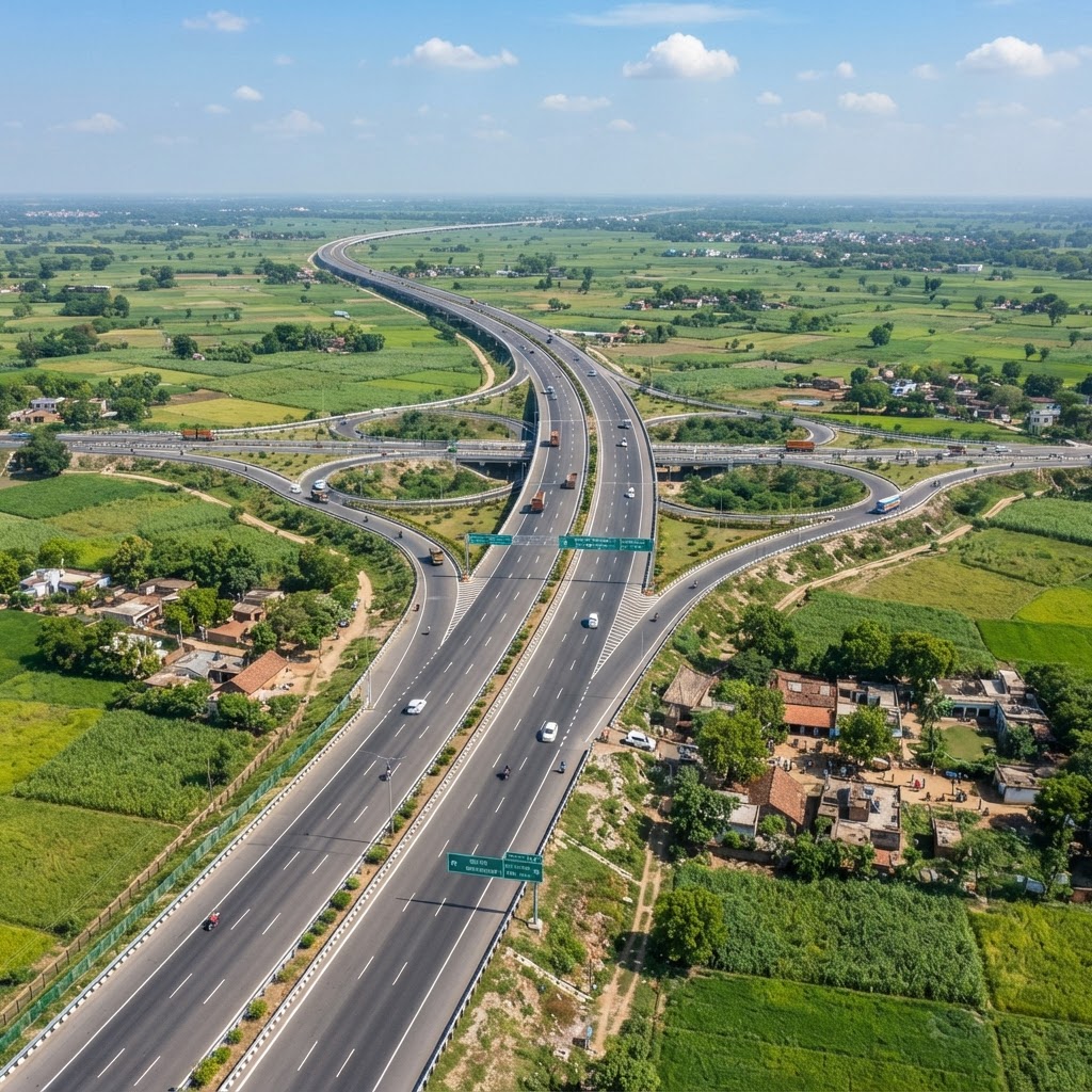
Table of Contents
- Ganga Expressway: India's Northern Powerhouse Project
- Route and Connected Districts
- Engineering Features and Specifications
- Construction Timeline and 2026 Progress
- Economic Impact and Regional Development
- How Ganga Expressway Stacks Against Delhi-Mumbai and Golden Quadrilateral
- Toll Pricing and Travel Cost Breakdown
- Real Estate and Land Acquisition
- Environmental Mitigation and Sustainability
- Conclusion and Future Prospects
- Frequently Asked Questions
Ganga Expressway: India's Northern Powerhouse Project
The Ganga Expressway is more than just a highway. It's a strategic corridor designed to fast-track Uttar Pradesh's integration into India's national economic fabric. Approved by the Union Cabinet in January 2021, the project received accelerated funding in the 2022–23 Union Budget and subsequent allocations, with ₹50 crore emergency funding approved in February 2025 to overcome construction delays.
The expressway is named after India's most culturally and spiritually significant river — the Ganga — whose basin encompasses the majority of the expressway's route. It directly serves Meerut, Hapur, Bulandshahr, Amroha, Sambhal, Badaun, Shahjahanpur, and Hardoi districts, connecting approximately 12 major towns and 50+ smaller municipalities with populations totalling over 40 million people.
According to NHAI projections, the expressway will handle 40,000–55,000 vehicles daily by 2035 (Average Daily Traffic or ADT), with peak capacity utilisation of 60–70%. This makes it one of India's busiest prospective expressways, comparable to the Delhi-Mumbai Expressway in significance and traffic potential.
Route and Connected Districts
| Segment | From | To | Length (km) | Key Cities |
|---|---|---|---|---|
| Section 1 | NH-334 Junction, Bijauli (Meerut) | Chandner Junction, Hapur | ~50 | Meerut, Hapur |
| Section 2 | Chandner (Hapur) | Mirzapur Dungal (Amroha) | ~75 | Bulandshahr, Amroha |
| Section 3 | Mirzapur (Amroha) | Nagla Baraha (Sambhal) | ~80 | Sambhal, Badaun |
| Section 4 | Nagla Baraha (Sambhal) | Prayagraj (Shahjahanpur link) | ~280 | Badaun, Shahjahanpur, Hardoi, Lucknow, Prayagraj |
| TOTAL | Meerut (NCR Region) | Prayagraj (UP) | 594 | 8 Districts, 12 Major Towns |
The expressway starts just outside Delhi's metropolitan region (Meerut), making it a crucial gateway for National Capital Region (NCR) traffic heading towards Uttar Pradesh's heartland. It terminates at Prayagraj (formerly Allahabad), a city of 5 million people and a major religious and educational hub.
Engineering Features and Specifications
- Six lanes standard: 3 lanes in each direction; expandable to 8 lanes in high-traffic zones (e.g., near Meerut, Lucknow approaches).
- Access-controlled (Limited Access): Entry/exit only at designated interchanges; no at-grade intersections. This design maintains high speeds and safety.
- Design speed: 120 km/h (similar to Delhi-Mumbai Expressway); allows safe, comfortable driving for long-distance freight and passenger vehicles.
- Airstrip facility: A unique feature — a 3.5 km long, dedicated airstrip adjacent to the expressway near Lucknow, enabling rapid cargo and emergency medical transport.
- Bridges and overpasses: 89 major bridges, 450+ minor bridges to cross rivers (Ganges tributary systems), canals, and smaller waterways.
- Service areas and rest stops: Planned at 50 km intervals; each will include fuel stations, restaurants, accommodation, and medical facilities.
- Smart highway technology: Real-time traffic monitoring, electronic toll collection (FASTag), variable message signs, and emergency communication systems.
- Width standards: 30 metres right-of-way for the main expressway; 50+ metres in urban approach zones.
These specifications place the Ganga Expressway at par with modern European and international expressway standards, setting a new benchmark for Indian highway construction.
Construction Timeline and 2026 Progress
Approved: January 2021 (Cabinet approval)
Land Acquisition: 2021–2023 (₹8,000+ crore in compensation)
Construction Start: April 2021 (Phased across 4 packages)
Target Completion: Originally December 2024; revised to early 2026 (with February 2025 emergency funding approval)
Current Status (July 2026):
As of July 2026, the Ganga Expressway is in its final stages of construction, approximately 84–87% complete across all sections. Key progress milestones:
- Section 1 (Meerut–Hapur): 95% complete; targeted opening August 2026.
- Section 2 (Hapur–Amroha): 88% complete; opening expected September 2026.
- Section 3 (Amroha–Sambhal): 82% complete; opening late 2026.
- Section 4 (Sambhal–Prayagraj): 78% complete; full opening expected Q1 2027.
Phased openings (rather than single day launch) are strategically beneficial: they allow toll plaza testing, traffic management trials, and safety validation before full capacity deployment.
Key contractors include Larsen & Toubro (L&T), Hyundai Engineering & Construction, and Ashoka Buildcon — ensuring high-quality execution and timely delivery.
Economic Impact and Regional Development
| Impact Category | Metric | Estimated Benefit |
|---|---|---|
| Travel time reduction | Meerut to Prayagraj | 14 hours → 6 hours (57% reduction) |
| Fuel savings (annual) | Per vehicle using expressway | ₹5,000–₹8,000 per year |
| Employment creation (construction) | Direct + indirect jobs | 150,000–200,000 jobs |
| Economic output (operational phase) | Annual contribution to state GDP | ₹2,500–₹3,500 crore by 2030 |
| Agricultural market access | Farm gate to consumer | Reduced perishable spoilage by ~25% |
| Manufacturing relocation | Industries moving to UP | ₹1,000+ crore FDI expected (3 years) |
| Urban real estate | Property prices (near nodes) | 25–40% appreciation within 2 years |
The Ganga Expressway will unlock agricultural transformation in North India. Uttar Pradesh is India's leading sugar cane, wheat, and rice producer. Currently, rural farmers face 2–3 day transport delays from field to market, causing ~20–25% spoilage on perishable goods. The expressway will reduce this to 4–6 hours, directly improving farmer incomes and reducing food waste.
Additionally, manufacturing clusters are expected to emerge along the expressway route, particularly near Lucknow and Shahjahanpur, attracting automotive, food processing, and pharmaceutical industries seeking proximity to both Delhi markets and production-cost-efficient Uttar Pradesh.
How Ganga Expressway Stacks Against Delhi-Mumbai and Golden Quadrilateral
| Expressway | Length (km) | Cost (₹ crore) | Cost/km | States Connected | Status (2026) |
|---|---|---|---|---|---|
| Delhi-Mumbai Expressway | 1,380 | 98,000 | ₹71 crore/km | Delhi, Haryana, UP, Rajasthan, MP, Gujarat | 90% complete; opening 2027 |
| Ganga Expressway | 594 | 37,350 | ₹63 crore/km | UP only (intra-state) | 84% complete; opening late 2026/early 2027 |
| Golden Quadrilateral (old benchmark) | 5,846 (all 4 sides) | ~60,000 (total historical cost) | ₹10–₹15 crore/km (2000s costs) | 4 metro-regions (N, S, E, W) | Operational since 2012 |
Compared to the Delhi-Mumbai Expressway (₹71 crore/km), the Ganga Expressway at ₹63 crore/km represents better cost efficiency, largely due to less urban land acquisition in UP and fewer urban approach complexities. However, both represent significant investment in modern, smart highway infrastructure that supports India's 2030 digital and economic growth targets.
Toll Pricing and Travel Cost Breakdown
The Ganga Expressway will use FASTag-based electronic toll collection (ETC), with toll rates dynamically priced based on distance and vehicle category:
Estimated Toll for Full 594 km Journey (Meerut to Prayagraj):
- Car/SUV: ₹1,500–₹1,800 (₹2.50–₹3.00 per km)
- Commercial vehicle (HCV/LCV): ₹2,200–₹2,800 (₹3.70–₹4.70 per km)
- Two-wheeler (two-wheeler tolls expected to be waived or minimal): ₹200–₹400 (across the entire route)
- Electric vehicles (EVs): 10–25% discount; aligned with government EV adoption incentives
Cost comparison — Meerut to Prayagraj:
- National Highway (old route): 14 hours, ~500 km via NH-19, toll ~₹1,000–₹1,300, total cost per car ~₹3,500–₹4,500 (includes fuel + time loss).
- Ganga Expressway (new route): 6 hours, 594 km, toll ~₹1,500–₹1,800, total cost per car ~₹2,500–₹3,200 (lower fuel + time savings = net savings ₹1,000–₹1,300 per trip).
For trucking/freight companies, the time savings translate to 1–2 additional revenue-generating trips per week, justifying the toll investment within months.
Real Estate and Land Acquisition
The Ganga Expressway has triggered significant real estate speculation and activity along its route. Key metrics:
- Land acquisition cost: ₹8,000+ crore; approximately 50,000–55,000 hectares acquired from farmers and property holders.
- Average compensation per hectare: ₹15–₹20 lakh in rural areas; ₹40–₹60 lakh in periurban zones.
- Appreciation in nearby property (2021–2026): 25–40% in towns like Meerut, Bulandshahr, Shahjahanpur; 50%+ in Lucknow's expressway corridor approach.
- Commercial real estate opportunity: Nodes (interchange zones) expected to attract retail, hospitality, and logistics clusters worth ₹500+ crore by 2030.
Environmental concerns regarding land acquisition in forest zones (near Hardoi district) have been managed through reforestation commitments and wildlife corridor preservation.
Environmental Mitigation and Sustainability
The Ganga Expressway incorporates modern environmental standards:
- Overpass bridges in biodiversity zones: Allow wildlife crossing without road deaths; particularly important for elephant corridors in Hardoi district.
- Rainwater harvesting and wetland restoration: Project includes 50+ water conservation structures along the route.
- Noise barriers in residential zones: Sound-absorbing barriers near settlements; expected noise reduction of 15–20 dB.
- Emission reduction through better traffic flow: By reducing congestion, the expressway is projected to lower CO₂ emissions by 8–12% on competing routes.
- EV adoption incentive integration: Charging stations will be deployed at service areas; 5–8% of service areas dedicated to EV infrastructure by 2028.
Modern infrastructure projects like this support India's broader climate goals, aligning with the 2070 net-zero emissions commitment.
Conclusion and Future Prospects
The Ganga Expressway represents a watershed moment for North India's connectivity, economics, and regional development. By late 2026 and early 2027, this 594 km corridor will shrink 14-hour journeys into 6-hour commutes, unlock 40+ million people's economic potential, and establish a new model for intra-state expressway development in India.
For commuters, farmers, and businesses, the Ganga Expressway is not merely a highway — it's a catalyst for transformation. For India's broader infrastructure narrative, it demonstrates that world-class, smart, sustainable expressways are no longer distant aspirations but present-day realities.
Watch for Section 1 opening in August 2026 — and expect cascading economic announcements from logistics companies, agricultural processors, and automotive manufacturers over the following 12 months.
You May Also Like: Delhi-Mumbai Expressway: India's Longest Highway Corridor, India's Dedicated Freight Corridors: Transforming Rail Logistics in 2026, and Indian Railways in 2026: Inside the Vande Bharat Boom, Freight Corridors and the Modernisation Push.
Frequently Asked Questions
When will the full Ganga Expressway open?
Phased openings: Section 1 (Meerut–Hapur) August 2026; Section 2 (Hapur–Amroha) September 2026; Sections 3–4 late 2026 and Q1 2027. Full end-to-end operation expected Q2 2027.
What is the toll cost for a car from Meerut to Prayagraj?
Approximately ₹1,500–₹1,800 using FASTag; discounts available for EVs (10–25% off). Online calculators will be available on the NHAI website.
Will the old NH-19 route still be used?
Yes, but traffic will shift 60–70% to the expressway for medium–long distances due to faster travel and fuel savings despite toll costs.
Are there service areas, fuel stations, and rest facilities?
Yes. Service areas at 50 km intervals will include fuel, food, accommodation, and medical facilities. Full amenity rollout by Q4 2026.
Is the Ganga Expressway safe for night driving?
Yes. Highway lighting, emergency communication systems, and 24/7 toll plaza presence provide high safety standards. Average accident rates expected to be 40–50% lower than NH-19.
Will there be restrictions on commercial vehicles?
Commercial vehicles allowed 24/7; no time-of-day restrictions. Some weight restrictions may apply during monsoon (June–September) on minor bridges.
What is the airstrip facility for?
The 3.5 km airstrip near Lucknow enables cargo operations (e.g., perishable exports to airports) and emergency medical evacuations, directly supporting regional economic development.